We have information about 18 river traces located around Yilan, East Taiwan
-
Jay
River:
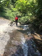
石門溪 / Shimen creekArea:
YilanRegion:
EastStart:
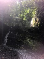
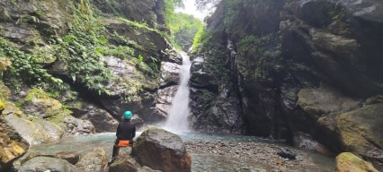
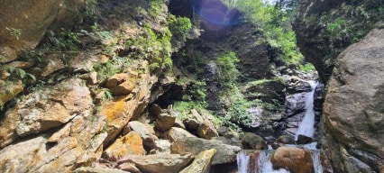
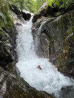
24.95185,121.91021The first waterfall is at 24.96,121.9085. It's 4 meters and has a nice pool to chill. On top of it are another two pools and you can jump into them. Trace further up for another 40 minutes-1 hour and you'll get to a 8-m waterfall. If you go above the 8-meter waterfall, two really tall waterfalls are around the corner. The one on the main stream is ... around 20-25 meters tall, and the other one on the left fork is also around that height. We went around the waterfall on the right side(facing downstream) and did a little bushwhack, but it was quite easy in general. There's webbing and a rope on the other side but it looked very sketchy to climb up, so we didn't go up on the left side(facing downstream). Shimen Creek is not only easy but also quite traffically available, just a train ride and a taxi from Dali 大里 or Daxi 大溪 station and you'll get to the trailhead. -
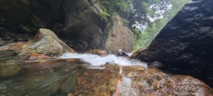
River:
仲岳溪 / Zhongyue creekArea:
YilanRegion:
EastStart:
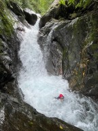
24.41518,121.73927I visited the location a week after the typhoon had passed, resulting in the waterflow being 2.5 times its usual rate. I believe tracing the path is much easier under normal waterflow conditions. On that day, I encountered numerous waterholes. We drove down to the end and began walking along a trail towards the GPS spot. The creek serves as a water ... source for the village below, with visible pipes. The first waterfall was particularly enchanting, featuring a beautifully serene pool in front of it (I'm uncertain if it was at coordinates 24.41096, 121.73626). Up until this point, the creek was characterized by large rocks and a swift current, without anything noteworthy to document. As we approached the final waterfall, the boulders grew larger, and the terrain became steeper. 300 meters away from the destination, we walked around along the mountainside on the right side of the creek (facing downstream). We descended into the valley on a rope I set up to a tree, and left it there for our return. Close to where we descended with the rope, we encountered the most challenging part of the river tracing. A precarious rope was hanging in a strong current. Due to the high risk and time constraints (we had set off late), I initially considered retreating. However, David (The Map Room) managed to climb the rope, which had been there for who knows how long. I was reluctant to use the same rope, so I passed my rope to him to set up a rope for me to cross the boulder. The potential danger was immense – being swept away by the powerful current or the rope breaking could lead not only to a dangerous fall but also to potential death from the waterhole (as everything seemed like a waterhole that day). I asked about his assessment of the climb, and he estimated an 80% chance of success. Well, not my style, but he's much stronger than me. On the return journey, we rappelled down instead of using the rope in the water. Around 100 meters beyond the previous obstacle, there was a 15-meter slanted waterfall. We circumvented it on the left side. Although there were two small ropes visible (which I didn't use), the area in front of the waterfall presented challenges. If you managed to reach this point, you should be relatively fine here. The rocks were extremely slippery here. We witnessed the tremendous rush of water cascading from the height of 45 meters into a pool and roaring through the gorge. Adjacent to the pool, the water was squeezed between two large rocks, creating a secondary 3-meter waterfall as it dropped. The sight was truly amazing, leaving us both astounded and thrilled. However, the journey wasn't over. A path existed on the right side of a large rock (facing downstream). David managed to climb over, but he was uncertain about the stability of the worn rope hanging there. I secured a rope and slings around the rope anchor for safety. Upon climbing up to the anchor rock, the powerful current was right beside and below us, flowing between the two massive rocks. With caution, we descended and walked through the water while holding onto the rope. The water level was so high that it reached my chest. It weirdly reminded me the time in the gorges of Jianianduan when I fought against currents. Finally, we reached the front of the waterfall. It has a resemblance to Yuemeikeng but with a waterflow seven times stronger. During our return, I held a rope attached to David and descended first, carefully seeking footholds and avoiding potential waterholes. Then, I guided him down. At high water flow, the difficulty is undoubtedly at a 5/5 level. I can't speculate on how this would be under normal waterflow conditions--definitely much easier! -
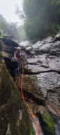
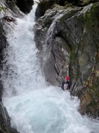
River:
南澳北溪 / Nán'ào běi xīArea:
YilanRegion:
EastStart:
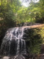
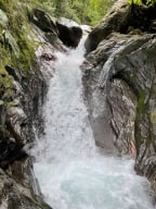
24.50342, 121.74538When we arrived, the typhoon had left less than two weeks ago, so the water level was about 2 to 2.5 times higher than normal. This river tracing/stream hiking route involves a great deal of climbing, so you really need to be skilled at climbing or have significant experience. Moving through the rocks feels somewhat like navigating a maze, similar ... to the childhood game called NS-SHAFT. It's a good idea to take note of the terrain when you hike up, as it will make the return journey easier. During the ascent, I used climbing slings a few times to help my teammate. The return journey was more challenging, requiring the use of climbing slings more frequently (webbing was also used). If you come here, make sure to bring a headlamp. Recommended equipment includes at least webbing and rope loops, and if you want to go up around the final waterfall, rope will be needed. This waterfall is incredibly impressive, with one side consisting of a suspended canyon formation. Enormous rocks hang precariously, creating an awe-inspiring atmosphere. The area around the waterfall is enclosed, and while the water volume is substantial, the pools are not very deep. I nicknamed it "Her Majesty Waterfall" due to its majesty. -
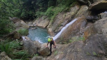
River:
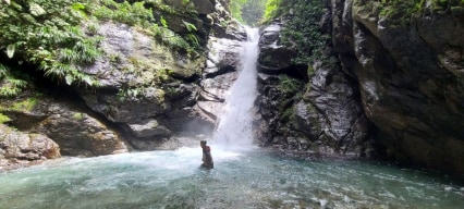
楠溪 / Nan creekArea:
YilanRegion:
EastStart:
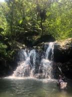
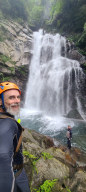
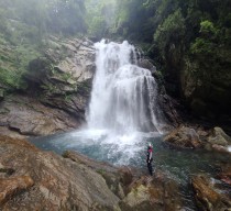
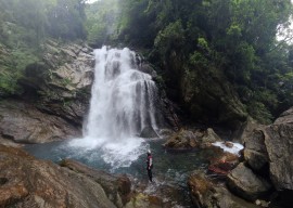
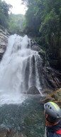
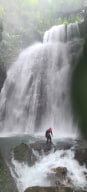
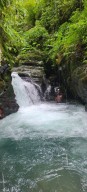
24.4237,121.70778Nan Creek is a tributary of Nan'ao South River. Nan'ao South River is usually a calm river but can be somehow scary after typhoon or a downpour. The waterfall in the picture is only 100 meters from the main river. It has a small beautiful canyon. -
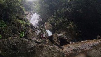
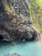
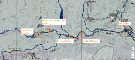
River:
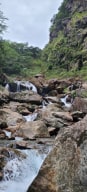
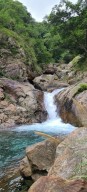
得子口溪 / Dezikou creekArea:
YilanRegion:
EastStart:
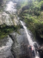
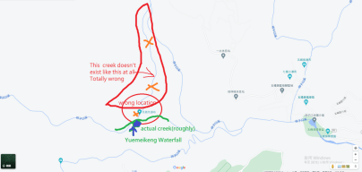
24.831193426175336, 121.74668290581367This is about the river tracers' route. If you take the tourists' mountain trail. Things would be much easier. On a trace, people usually trace up from the steel bridge(24.8303888,121.7385734) and go back on tourists' route from Yuemeikeng Waterfall. Because river tracing back takes a lot of time. The starting point is a parking lot, but it is extre ... mely stuffed with cars on weekends because the area is a popular tourist attraction. Therefore, taking a taxi or riding a scooter here from the bus or train station is a reasonable choice. First, walk across the bridge of big pipes to the trail from the starting point. Then hike up the trail for 15 minutes, and you will see the starting point in the creek, by a thin steel bridge. When you see a land god shrine on your way, you are almost to the creek. Remember to choose the right trail fork after the land god shrine. There is a creek fork almost right by the starting point of the creek. You should follow the mainstream first, which is the left one. Trace up for 15 minutes, and you will the other creek fork; this time you have to choose the right fork. Trace up here for 15 minutes, there should be a gorge. There are two ways to go up. One is to climb up the waterfall, and the other is to climb around on the right side(facing downstreams) of the creek. The former is only doable with low waterflow, and the use of rope is suggested. The latter, however, requires tracers to climbing on a vertical wall at the height of 3.5 meters with some rope; it is pretty challanging even risky to unsporty people. There is another waterfall right above the lower one. The pond between the two waterfalls is very deep and good for jumping. But the climbing-up next to the second waterfall is even more challanging--a gap of 5 meters with barely any footholds and slippery rock face. Even though there should be a piece of thick rope with many knots, it is still the most challanging part of climbing--I even struggled there. If you climb on the wall on the right side of the creek instead of climbing up right through the lower waterfall. You will end up at the top of the second water and will not need to climb this difficulty gap. Yuemeikeng Waterfall now is 30 minutes away. The creek is surrounded by rainforesty trees and ferns, and this part of the trace is relatively easy. But the joy of a few gaps and pools on the way will bring you an impressvie experience. Finally, you will be met by a big waterfall at the height of 45 meters, and that is Yuemiekeng Waterfall. On you way back, you can take the tourists' route to get back. There are two ways to do so. One is to hike up on the right side(facing downstreams). This is a detour route but much clearer than the other. The other is to trace downstreams back for 5-10 minutes along the creek. There is a rough trail and it is sometimes interrupted by the creek itself. The trail that leads you back to the mountains can be found at here, on the left side of the creek(facing downstreams)(24.8310332,121.7354250).